(→Season 2: added episode name of taco restaurant) Tag: Visual edit |
(→Season 2: added episode name of rosarito beach hotel) |
||
| Line 40: | Line 40: | ||
* [[Magana's Tacos Restaurant]]: Colonia Santa Anita, Baja California, Mexico ( Season 2, Episode 10, "[[Do Not Disturb]]") |
* [[Magana's Tacos Restaurant]]: Colonia Santa Anita, Baja California, Mexico ( Season 2, Episode 10, "[[Do Not Disturb]]") |
||
| − | * [[Rosarito Beach Hotel]]: Rosarito Beach Hotel and Spa, Rosarito, [[Baja California]], México <ref>http://www.rosaritobeachhotel.com/rosarito-beach-hotel- </ref> ( |
+ | * [[Rosarito Beach Hotel]]: Rosarito Beach Hotel and Spa, Rosarito, [[Baja California]], México <ref>http://www.rosaritobeachhotel.com/rosarito-beach-hotel- </ref> (Season 2, Episode 9, "[[Los Muertos]]") |
==Season 3== |
==Season 3== |
||
Revision as of 14:06, 3 October 2017
Season 1
- Abandoned Church: Pilgrim Church, Silver Lake, Los Angeles, California, USA [1]. (Season 1, Episode 1, "Pilot" )
- Sunset Triangle Plaza: Sunset Triangle Plaza, Silver Lake, Los Angeles, California, USA [2]
- Paul R. Williams High School: Woodrow Wilson High School, El Sereno, Eastside Region, Los Angeles, California, USA [3] (Season 1, Episode 1, "Pilot" )
- Temple Community Hospital: Temple Community Hospital, Rampart Village, Los Angeles, California, USA [4] (Season 1, Episode 1, "Pilot" ). After decades of providing service to the community, it closed due to insolvency.
- Freeway Incident: (See Emergency Services page) Southbound along Long Beach Freeway (Interstate 710 or I-710) , in approach to westbound direction of the San Bernadino Freeway (I-10) Interchange, East LA, Los Angeles, California, USA [5] (Season 1, Episode 1, "Pilot" ).
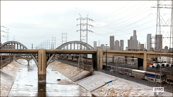
In the United States, the lnterstate designation works as follows: all even numbered roads go East to West, and the odd numbered roads go North to South. Any number prefixed in front of those designations, refers to a road which rings around the metropolitan area of a major city like the I-710 near Los Angeles for example. - Sixth Street Bridge: Sixth Street Bridge, Downtown Los Angeles, Los Angeles California, USA [6]. Note, the bridge was demolished in 2016 due to cited concerns of seismic instability[7] (Season 1, Episode 1, "Pilot" )
- Venice Beach: Venice Beach, Los Angeles, California, USA [8] According to Google Maps the Beach is less than 20 miles from Downtown Los Angeles (Season 1, Episode 1, "Pilot" )
- Diner: Denny's (American Casual Dining Chain Restaurant), Downtown Los Angeles, Los Angeles, California, USA [9] (Season 1, Episode 1, "Pilot" )
- Salazar's Cuts: Downtown Eastside, Vancouver, British Columbia, Canada [10] (Season 1, Episode 2, "So Close, Yet So Far")
- Gabrielinos Plaza : Oceanic Plaza, Downtown Vancouver , Vancouver, British Columbia, Canada,(Season 1, Episode 3, "The Dog")
- Sisters of Mercy Hospital: Surrey School District Education Centre, Surrey British Columbia, Canada [11] (Season 1, Episode 3, "The Dog")
- Dodger Stadium: Dodger Stadium, Elysian Park, Los Angeles California, USA [12] (Season 1, Episode 3, "The Dog")
- Los Angeles Memorial Sports Arena: Pacific Coliseum , Hastings Park, Vancouver, British Columbia, Canada. (Insert Season Number, Episode Number, Episode Name)
- Strand home: Ranchos Palos Verdes, Los Angeles County, California, USA [13] (Season 1, Episode 6, "The Good Man")
- Sunken City: Sunken City, San Pedro, Los Angeles County, California, USA [14] (Season 1, Episode 6, "The Good Man")
")
Sunset Triangle Plaza
")
Sixth Street Bridge
")
Venice Beach
")
Long Beach / San Bernadino Freeway
")
Diner
")
Gabrielinos Plaza
")
Dodger Stadium
")
Sunken City
")
Source: https://www.google.com/maps/d/embed?mid=16wxTWOoCMmTMTaqBfyOpZvIFJ0w
Season 2
- Magana's Tacos Restaurant: Colonia Santa Anita, Baja California, Mexico ( Season 2, Episode 10, "Do Not Disturb")
- Rosarito Beach Hotel: Rosarito Beach Hotel and Spa, Rosarito, Baja California, México [15] (Season 2, Episode 9, "Los Muertos")
Season 3
- Gonzalez Dam: Abelardo L. Rodriguez Dam, Tijuana, Baja California, Mexico [16](Season 3, Episode 3, "Teotwawki")
- Mexicali Trading Post (El Bazar): Plaza Monumental de Tijuana, Tijuana, Baja California, Mexico (Season 3, Episode 10, "The Diviner").
Point of Disclosure, in the United States The Diviner, in conjunction with Minotaur, was shown as part of a two episode premiere, so any information in those pages may be intermingled.
")
Mexicali Trading Post
References
- Please note the references to Season and Episode number is in regards to when it first appeared, not the number of times it appears throughout the series.
- ↑ https://moviemaps.org/locations/3t8
- ↑ http://www.seeing-stars.com/Locations/FearTheWalkingDead.shtml
- ↑ https://moviemaps.org/locations/3t2
- ↑ http://www.latimes.com/business/la-fi-hospital-closes-earthquake-retrofit-20140917-story.html
- ↑ http://www.seeing-stars.com/Locations/FearTheWalkingDead2.shtml
- ↑ http://www.seeing-stars.com/Locations/FearTheWalkingDead2.shtml
- ↑ https://en.wikipedia.org/wiki/Sixth_Street_Viaduct
- ↑ http://www.seeing-stars.com/Locations/FearTheWalkingDead2.shtml
- ↑ http://www.seeing-stars.com/Locations/FearTheWalkingDead2.shtml
- ↑ https://moviemaps.org/locations/3t6
- ↑ http://yvrshoots.com/2015/05/shoot-fear-the-walking-deads-fresher-more-human-zombies-at-hospital-set-in-surrey.html
- ↑ http://www.seeing-stars.com/Locations/FearTheWalkingDead5.shtml
- ↑ http://www.seeing-stars.com/Locations/FearTheWalkingDead7.shtml
- ↑ http://www.seeing-stars.com/Locations/FearTheWalkingDead7.shtml
- ↑ http://www.rosaritobeachhotel.com/rosarito-beach-hotel-
- ↑ http://www.amc.com/shows/fear-the-walking-dead/cast-crew/lola-guerrero